Migrate your logs from analog to digital and access your information from anywhere at any time.
Location Data Services has developed a secure and affordable data and mapping solution specifically for lobster fishermen to track their catch and visually perform time and quantity analysis on the data to help them make informed decisions on future trap placement and configuration, observe trends, and track quantities over time.
The Lobster Tracking solution can be tailored to fit your needs. Please reach out for more information or request a quote to get started.
Capture Data
Using the app, enter the number of lobsters caught at each buoy. This is a simple 3 tap process that records the number entered by the fishermen, the number of traps tied to the buoy, and the GPS location of the boat at the time the data is entered. As soon as the data is recorded, it is securely sent to our database if the user is within cell range. If the user is out of range, the data is stored on the device until the boat is back in range.
Each record is tagged with date and time information and the login name that entered the data. The data is secured to the Individual boat and is never shared without the approval of the fisherman.


Visualize the Data
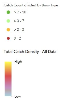
As data is collected, the users can begin to perform their own analysis. View the data based on average lobsters per trap, view total catch densities, filter the data by time and quantity and begin to make more informed decisions on trap placements and configurations.
Know the Numbers
Using the data captured with the app, track individual catch totals for the day, week, and month and view progress toward any preset goals. Using dashboards can help wholesalers see what their suppliers are catching in real time and know what to expect before the boats return to the docks.

Data Security
At no point will Location Data Services share or sell data or incorporate it into other datasets or products without the written permission of the subscriber.
Users of the application will have their data secured independently of all other users. We use an industry standard platform to store and secure your data. ArcGIS Online is used in nearly every industry and many fortune 500 companies rely on this platform to store and secure their geospatial data.
While there is great potential in this data for fishermen that wish to collaborate or industry organizations wanting to show the impact of new regulations on fishing grounds, participation in these efforts are strictly voluntary. Should the subscriber wish, mutual NDAs can be issued.